Friday, December 22, 2017

Welcome to the party!

Isa Rosso

Me!!!
We are on our way towards the third CTD station, where the second SOCCOM float will be deployed! 

Few thoughts.. Today was laundry day: I just realized the second week has passed.. Funny, I think there’s a standard number of days after which you suddenly realize you have your own routine, schedule, plan for the day. In my case varies between 7 and 14.

As I anticipated in my previous post, I had my first birthday onboard. My new group of friends have organized my very first surprise party!! At midnight of the 16th, my roommate tells me that she wanted to go out to take some pictures. Despite my question mark painted on my face (I don’t know what the temperature was outside, but definitely not comfortable), I followed her.. And at the heli hangar, my group was there, singing me a Happy Birthday song that they wrote for me!! <3 my heart exploded!! And then the night started, with chocolate cake, dances, presents, songs.. and a bit of rhum ;-) It was fantastic, and I’ll never forget it!!

The ocean just turned into that gray shade, typical of these latitudes. These furious ocean and howling wind make me feel like at home. We just left the Roaring Forties, and approaching the Furious Fifties, towards 54S. The winds here are indeed no joke! We went outside after dinner, on the 4th deck.. The wind is so strong that you have to hold on to something (or someone) to keep your balance! All around.. there’s the white of the overcast sky, and the mist towards the horizon.. very gloomy. We are very close to the Kerguelen Islands at this point: I checked, but there’s no sign of them (see picture ;o) ).


In these past days, we had few scientific activities planned, the biggest being the recovery of the mooring which was deployed the last year. Unfortunately, after a 2-day search and wait, the mooring was not found. There’s still some hope on the way back, and I truly wish for the group who deployed it to find it! Lots of precious data are awaiting somewhere in the depths of the dark ocean to be rescued.. and their secrets to be told.


Thursday, December 21, 2017

Sandy's in the STORM!

Isa Rosso


OH MY!!! These days have been really “rock & roll”!! And not only for my guitar skills that are improving.. ehee!! Small waves, big waves, this ship doesn’t care. It’s like being on a rollercoaster. I love it..! hehe Not so much a shared feeling by those poor souls who got seasick from the very first day.. and still cannot get over it. 

Especially today.
Sandy the float -- before the storm
The weather has put us in stand by, but finally around lunch time today we started the CTD casts (6 in total), to collect water samples, from 2000 m up to the surface, plus others from 200 m to the surface samples, for biological studies. The rosette (soon I’ll post a photo) is one tiny little guy, with only 12 niskin bottles (used to collect the water at different water depths). I got my samples, sealed the pH bottles and froze the nutrients. After the CTD casts, we had another couple of operations at the same station location, and after that we got to deploy the first SOCCOM float of the SOE10 expedition!!!! Woohoo!! This is always a great moment for me, I feel a lot of responsibility, I want everything to go smoothly and then I can’t wait to see the first data coming in!! 

Sandy” is the name of the deployed Navis #0690 float, named by the class at Long Beach Island Grade School (NJ). They chose this name, as it has a significant importance for the students, due to the impact that this storm had on their school and community on Long Beach Island. Now.. we deployed Sandy at 40 kn wind!!! Just before that, we almost flew from one side of the helicopter deck to the other. Bottles fells, boxes, gears, my guitar (!!!) all got shifted (I should say thrown) to a different location. Quite dramatic! Sandy does really call for a big storm!! The deployment, which was exceptionally perfect considering the huge swell and the strong wind, was at 40 02.4209S, 57 37.2273E on December 15, 2017 at 16:39 UTC.


You can follow its life on the SOCCOM website. Just search for the float with number 0690, and easily plot its profiles, or download its data… once the first profile comes in ;-)
Dramatic deployment

Me. Taking pictures of birds. While doing silly faces. 
Tomorrow is my birthday, and like every year, I feel a little bit pensive. I celebrated my birthday on a plane (twice), in 3 different continents, but on a vessel in the Southern Ocean, with such a rough weather, it’s pretty unique! Hopefully some whales will come celebrate with me tomorrow ;-)


And to finish with some wildlife: the first petrels and beautiful albatross appeared, with their elegant way to cut through the wind (sometimes they fly so close to the ocean and just touch the waves with the tip of their feathers.. I could spend hours looking at their mesmerizing dance). Then, we had some dolphins playing in front of the bow. Uh!! And a sunfish came to check on the ctd while we were on station!! That was really cool!!


Wednesday, December 20, 2017

2017 Southern Ocean Expedition - Indian Ocean

Isa Rosso


I’m back in the Indian Ocean’s water, after 2 years, and at sea again just after 4 months. My most recent expedition was in the Pacific Ocean as part of the US-GOSHIP repeat hydrography (you’ll find the blog for that expedition at usgoship-p062017.blogspot.com).

It’s quite exciting for me, to be in these waters again. Our track will bring us to the western side of the Kerguelen Plateau, a massive topographic barrier to the eastward flowing Antarctic Circumpolar Current, and then down to Antarctica. I have a special love for this area, as it has been the focus of my PhD thesis (see my previous blog on floatsherder.blogspot.com). 

I left San Diego on November 30th. Leaving home, especially saying goodbye to my husband Diego, is never easy. But both my friends and he always give me courage and support me no matter what, which makes the departure a little bit less painful. Armed with my big luggage, my guitar and a backpack with my camera and computer, I started my journey to the far Mauritius. I had a veeeery long flight and reached Mauritius about 30 hours and 3 flights later. The island is gorgeous, and people are just incredibly kind, smiling and helpful, and I had a wonderful day and half to recover from the long flight and prepare the last things before departure.
ARV I at the port 


We were planned to leave on December 7th, but we had several issues, first a delay with the delivery of the floats and gear, and then some technical problems at the ship, the R/V Agulhas I. We finally left port on December 9th, 2017, at 12:00PM UTC. We had to go back to port for a medical evacuation just few hours later, but we are steaming now at full speed towards our first station, which is planned for December 14th, 3 days from now.

The vessel is the first South African icebreaker, now used for training and some scientific expeditions, such as this one. There are 20 cadets onboard, and other 40 people between officers and ship crew. From the science party there are 41 scientists from several Indian Institutes, plus me from Scripps. Science activities cover both physical and biogeochemical oceanography, and atmospheric science. The expedition will be documented by Rakesh Roa, an excellent Scientific Documentary filmographer and photographer, former Physicist with a strong background in Astronomy. Yesterday night he gave Zoelle (the doctor onboard) and me an amazing 2-hour “lesson” of the sky, with its constellations, and stars, and identified Andromeda Galaxy, Large and Small Magellanic Clouds (which are other 2 galaxies). I can’t wait to know more!!
First sunset on the ship

My main duties onboard are deploying 7 biogeochemical profiling floats and collect water samples which I’ll send back to the US to be analysed for nutrients, pH/Alkalinity, and HPLC/POC. The floats are from the Southern Ocean Carbon and Climate Observations and Modeling project (SOCCOM, https://soccom.princeton.edu/), and have all been adopted and named by different classes from Middle and High Schools in the US, as part of the “Adopt-A-Float” program. Stay tuned to know more about these floats.. and see pictures!! 

Unfortunately, we don’t have much internet capability, and we are all sharing 2 computers for sending emails. Internet is also super slow, and it takes me about 20 minutes to log into the email webpage.. So, I’m not sure how much I’ll be able to update the blog during the cruise, especially I’m not sure if I’ll be able to upload some photos. I’ll give it a try with this blog post and see how it goes :)
Beautiful fluffy clouds on the horizon


All for now.. Stay warm and enjoy these last days of 2017! :)

Friday, October 13, 2017

Team Work Makes the Dream Work!

From left to right: Chief Scientist Tahlia (as Luna Lovegood), Lelethu (Hogwarts Express), Melissa (birthday girl), Caitlin (dementor), and Mark (Hagrid).

Personalities within a science party can make or break a cruise. The five of us on this trip worked together very well and became great friends. There was a lot of down time as the ship performed its resupply and turnover missions. What could have been boring or even tedious was made magical due to our close bond. My birthday came during one of these down periods, and the team made the most of it. They threw me a surprise Harry-Potter themed party, complete with costumes and themed drinks. I make a big deal out of birthdays, but this one will hold a special place in my heart forever.


Before all going our separate ways when we got back to land (though the other 4 all live in Cape Town), we got together to take 'album cover' photos on the back deck. Dressed in the matching gear that the ship distributes to all scientists, we assembled for the photo shoot. Everyone had ideas for poses, and we had a lot of fun doing it. I will treasure this experience, and these pictures. I am so grateful to Tahlia, Lelethu, Caitlin, and Mark for the last 5 weeks - for their help when we had work to do, and their company throughout. #blessed


Olympians versus Titans

The launch of 'Olympians.'

Two SOCCOM floats were adopted by Desert Ridge Middle School in Albuquerque, New Mexico. They are named 'Titans' and 'Olympians' after the team names the sixth grade students chose for themselves after studying mythology.
Titans being tested in port. Cape Town's famous
Table Mountain in the background.2

The two floats were deployed in very different areas. Titans was launched during the run south we did after dropping off the turnover team at Gough Island. Three weeks later, Olympians was deployed about halfway between Tristan da Cunha and Cape Town.


Both are working great and have been sending profiles of data collected from their many sensors. You can follow them as they drift, and send back data every 10 days.
Follow this link. Titans is float #12723 and Olympians is #12733.


Underway Science

Lelethu and the pCO2 system in the underway lab onboard Agulhas II.

There is constant scientific analysis going on aboard Agulhas II, even when all the scientists are in bed. The ship has a pump that delivers surface seawater to the underway lab, where it is analyzed by machines that only need minimal attention (at least when it's working correctly!). Lelethu Nohayi, a technician from CSIR (Council for Scientific and Industrial Research), was in charge of the pCO2 system on this cruise. It measures the difference between carbon dioxide concentrations in the ocean versus the air just above the surface.
The 'wet box' (behind Lelethu in the above picture) recreates the air-sea interface using seawater pumped up from the bottom of the ship, about 5 meters below the surface, and air pumped in from the front of the bridge, which is uncontaminated by the ship's exhaust. The 'dry box' (on the left) consists of all the electronic components necessary for the measurements. 
Data can be collected constantly, and the pump was run every time the ship was underway. Lelethu also took samples that will be analyzed back in a shore-based lab in Stellenbosch that will be used to calibrate the system. pCO2 data has been collected all over the world by research vessels since the 1950s. This cruise will add to that important data set

Full Moon Deployment

Float Freddy Cougar ready for deployment.


Apologies for the late post. After the ship filled up again with passengers from Tristan da Cunha, internet bandwidth was hard to come by. We have now returned to Cape Town, South Africa and I am enjoying the small comforts I've had to do without for 5 weeks. Lightning fast internet and being able to decide what to eat are the biggest ones.


A SOCCOM float was deployed soon after we departed Tristan on our transit back to Cape Town. Probably the loveliest deployment of the cruise, it took place in calm weather, under the full moon.


Float 'Freddy Cougar' was adopted by Melvin Krepps Middle School in East Windsor, New Jersey and named after their mascot. I considered drawing a mash-up of a cougar and Freddy Krueger, but quickly decided it was beyond my very limited artistic abilities.


Perhaps you've heard the phrase 'fair winds and following seas.' It's what you say to sailors to wish them a safe voyage. While much more important to sailing ships, even a ship like Agulhas II benefits from good weather. On this particular night, we indeed had a following sea, which means that the surface current and swells are moving in the same direction as the ship. Before we stopped for the deployment, the ship was making nearly 14 knots with much less effort than usual.

However, a SOCCOM float need to be lowered into the water with the swell moving away from the ship, so that it does not get banged into the hull or run over. So in this case, the ship had to turn around in order to deploy the float. This is not without its own risk though, as after the deployment takes place, the ship has to turn around again in order to continue on its way home. With a good crew, like that which we had on Agulhas, it just takes some planning. The maneuver was performed successfully, and Freddy Cougar is hard at work!


Myself and the bosun's crew deployed the float in smooth conditions.


Microplastics in the Ocean

Caitlin collected surface samples using a bucket on a rope.
You can see the CTD A-frame deployed in the background.


Caitlin Kelly was onboard Agulhas II for the entire cruise collecting surface water samples for a microplastics study. The professor in charge of the project, Dr. Peter Ryan, was also on the ship, but was part of the turnover crew that went to Gough Island for a few weeks. He has been studying the effects of plastic on seabirds since his master’s project in the 1980s.


Plastic pollution in the ocean is probably something you've heard about before, and it's in the news more and more with the discovery of huge "garbage patches" around the world. Tiny pieces of plastic (microplastics) can be found in the surface waters of oceans all over the planet. 


The group came onboard with a vacuum filtration rig, but one of the glass components got broken in the first few days when we experienced bad weather. Not willing to sacrifice the opportunity to collect data, the team reverted to the low-tech approach developed on the Antarctic Circumnavigation Expedition by SAEON (South African Environmental Observation Network) biologist, Dr Tommy Bornman. Caitlin collected samples using a bucket on a rope, and then filtered that water through a 25 micron mesh filter using plastic cartons held together with duct tape.
Filter with fibers and particles clearly visible.


I was amazed that with my own eyes, no magnification, I could see fibers and colored particles on the filters after just 10 liters of water had been run through them. But it's perhaps not too surprising, because we were traveling through the edge of the South Atlantic gyre, where floating plastics and other debris accumulates. The filters will be analyzed by a lab in Italy, which uses a micro-FTIR spectrometer to pinpoint the type of material. 

Caitlin processed each sample by pouring the water
into a carton. The filter was held in place by the cap. 


Talking with Peter Ryan over dinner one night, I learned more about the huge threat that plastic poses our oceans. Since it does not biodegrade, most of the plastic ever made is still on the planet (unless it is incinerated or converted into fuel). Plastics slowly degrade through UV exposure and are battered into tiny pieces and distributed by surface currents. Some plastics are more dense than seawater and sink fairly quickly. Less dense plastics also sink once they become fouled with algae, barnacles, bacteria, etc. Which suggests that plastic ends up on the ocean floor, where it is harder to quantify and study. If you've ever been snorkeling, you've probably seen some trash tangled up in coral or floating by.


I have never been on a cruise with microplastic sampling, and it was interesting to see it in person. But also disheartening. Here we were in some of the most remote areas on the planet, and still surrounded by negative human impact. Understanding the distribution of microplastics is an important step to acknowledging the impact, and will hopefully lead to protections and a change in our behavior.

Tuesday, October 3, 2017

Helicopter Operations

The crew prepares for a flight.

The ship is filling back up again with passengers as we head into our final week of the cruise. We picked up last year’s Gough Island science team and turnover staff and are now back at Tristan de Cunha. For the previous two weeks, the five ship-based scientists have pretty much had the place to ourselves. Other than the ship's crew, there are twelve men that make up the helicopter crew who have been onboard the whole time. They did not get to join us during the unique down-time us scientists got on both Tristan and Gough Islands (see previous posts). Instead, they were busy shuttling passengers and cargo between the ship and the islands.
A container is flown to Gough Island.


There are two identical helicopters stored in the hangar on level 5, and they have flown both on this trip, though only one at a time. They are used for both scientific and logistic purposes. Containers full of supplies are brought out from the ship's hold and connected to a quick release device hanging down from the helicopter (see picture at left). At least one of the helicopter crew members are on the ground to ensure the containers are set down safely, and then the pilot presses a button to release the cargo. The process is reversed when bringing empty containers back to the ship.

It’s a very cool operation to watch from the sixth floor lounge, which has a bank of windows from which you can see the helicopter’s approach. It hovers over the deck in the space between the ship’s bridge and forward crane. Conditions have to be just right in order to safely conduct these operations, and the ship often moves to position the wind most favorably.

Flights were also taken to survey other areas of the island, and to drop scientists off at otherwise inaccessible areas. This turnover cruise is one of only a few times all year that a helicopter is available on each of these islands. A few trips were also taken when we were off-shore of Nightingale Island in order to supply the scientists who will live there for the next six months.


The crew are a friendly bunch of guys, ready to chat over meals; it's like having a bunch of uncles and cousins onboard. Many of them have visited the lab and I got a tour of the hangar and helicopter in return. Apparently over the course of this five week cruise, they will be in the air for a total of 20 hours. At first, this might not sound like much, but each run only takes a few minutes. Not to mention that during the days the ship is near the islands, the helicopter crew is basically always on call, as they need to take advantage of any good weather window. As you can see in the picture at the bottom of the page, there’s a GPS screen on the dashboard, just like in a car. In this case, it shows trip after trip between the ship and the base on Gough Island, as well as a few longer trips to other areas.
The twelve members of the Ultimate Heli team.
While waiting to get back to science operations, I've spent some time in the hangar observing maintenance, as well as the start up and shut down procedures. The blades can be rotated so that all four are in line with the body of the helicopter, so it takes up less space. Before each flight, the helicopter is rolled out onto the flight deck and engineers move the blades into position (see top photo). Fuel is added, the doors are put on, and a whole checklist of other operations are performed. On the cargo runs, one pilot, one co-pilot, and an engineers acting as a spotter are in the helicopter. Three men are dressed in fire gear and standing ready on the flight deck in case of emergency.
Many of the crew members have worked all over the world, often in remote areas. Even compared to their standards, a trip like this, to the most remote islands on Earth, must be something special. It takes the whole team to get the job done, and these guys really seem to enjoy the challenge.


Engineer Phillip spots for landing on Gough Island.
Agulhas II in the background.

Gough base as seen from the helicopter. Note the GPS on the dash.

Sunday, October 1, 2017

A Day on Gough Island


The ship's doctor and ship-based science party pose with Agulhas II during our outing to Gough Island.  
Earlier this week, I got to spend 24 hours on Gough Island, one of the most remote places on Earth. Inhabited by a team of scientists year-round, the Agulhas II is in charge of turnover. The ship brings out a new batch of birders, biologists, ecologists, and members of the South African weather service, who will spend the next year living and working on the island. There's a 2-3 week turnover period where the previous year's team trains the new one. Also on the island during this time are staff from the weather service, public works department, and other government agencies who have maintenance projects to conduct. At the end of the change-out period, last year's team and the turnover staff return to the ship. A fishing vessel or two will stop at Gough Island during the year before Agulhas returns, but that's about it. 
Gotta love a good Jurassic Park reference.


The science party was invited over to Gough Island this week for the turnover party. Everyone there has been working nonstop since we dropped them off before continuing with our ship-based science a few weeks ago. After a ceremony and speeches, we were treated to a feast, tables and tables of delicious food. Festivities went into the wee hours of the morning. The five of us ship-based scientists slept on mattresses on the floor of the movie room like it was a slumber party. The next morning we went for a hike. I did a mild walk to Seal Beach, while some of the others went on a 7-hour quest up the mountain looking for a wandering albatross nest (which they found). Appropriately enough, at Seal Beach I saw fur seals, lounging on warm rocks and swimming in a large tidepool. The nearby rocks were covered in nesting rockhopper penguins. For over an hour I just watched them, their facial fringe flapping in the wind. They inhabit rocks much farther from the waterline than I expected, and watching them make their way across boulders was both impressive and amusing. 


Yellow-nosed albatross on its nest.


There are many other bird species who nest on the island. During the hike, we saw multiple yellow-nosed albatross nests and could hear great shearwaters calling from their burrows all around us. On the cliffs, sooty albatross (my favorite) were gathered. I also saw dozens of Gough moorhen around the base. An endemic species (only found on Gough Island), the moorhens are related to a South American species that somehow ended up far from home. It's one of only two land bird species, the other being a bunting that I unfortunately didn't see. 


The ship has been hanging around Gough Island since we returned onboard. The helicopter teams move crates back onboard whenever the weather allows, and the crew also transferred fuel from the ship to the island's tanks. When there's no work going on involving the ship, it moves to a protected area out of the wind. Gough Island is absolutely gorgeous, with amazing rock formations and water falls. I consider myself very lucky to be one of very few people to ever see this beautiful place.
The protected side of the island, with the ship's bow in the fore-ground.
The helicopters land containers in the yellow circle.

Waterfalls along the coast of Gough Island.


A beautiful day for a hike on Gough Island.

Monday, September 25, 2017

Fishing Is Permitted

Crew members at the rail, with Gough Island in the background.

Each day here at Gough Island, once the helicopter operations are concluded or canceled due to weather, an announcement comes over the ship's PA system. "For the information of all hands, fishing is now permitted. Fishing is permitted." Within minutes, the forward deck is lined on both sides by crew members tossing hooked, baited, and weighted line overboard. So far I've seen them bring up three different species of fish, the fivefinger (which is brown with stripes like a bass), jacopever (bright orange), and bluefish (also called barrelfish or butterfish).

Crew member with a hefty bluefish.
During helicopter ops (more on that in a post later this week), the deck is cleared of any non-essential personnel as cargo is brought up from the hold and loaded in this area. 

I don't otherwise see too much of the crew, which is definitely a different experience for me. They eat in a different dining hall, and have a separate gym (and sauna). The ship is dry for them, so the only crew member we see in the bar is the bartender. It's nice to see many of them out on deck enjoying some leisure time once fishing is allowed. And they're all as keen as crew members and scientists alike on US ships that I've sailed with. 

They were all very friendly towards me today as I walked the deck as a tourist (I never cared much for the sport). I peeked at the catch, which is kept in buckets that used to contain oil for the kitchen friers. Only a few have the rods and reels I'm used to seeing, mostly it's just straight fishing line and a plywood block with their name on it to claim a spot (see photo above).

I'm glad to see that the crew gets a morale boost from the experience. They all work tirelessly to make this cruise successful. Tomorrow the scientists will get a bit of a morale boost, as we're being shuttled over to Gough Island for some sight-seeing. It will be nice to step foot on land, and in such a remote place. Stay tuned for more on that experience!

Sunday, September 24, 2017

Down Time

Trying to keep active on a ship that is only 450 feet from end to end is a challenge. Even when we're busy with science, there's lots of sitting and inactivity. Right now the ship is just off the coast of Gough Island, and will be for at least a week while helicopter and fueling operations take place. The small science party took two days to ourselves, each staying in our respective rooms watching movies and reading books, seeing each other only at meal times. But now we're a bit restless. Chief Scientist Tahlia Henry has been at sea often enough to know that we'll need distractions in order to stay in good spirits during this down time. Movie nights are being organized, as well as game nights and other events to get us out of our staterooms.
"Feel like the toes are buds ready to blossom in spring,"
is (no joke) the narration of this moment.
Before they left for the island, some of the women in the Gough science party were doing yoga sessions using the projectors in the auditorium. I copied a few files, but running south in rough weather wasn't really the right time. Today, though, it is calm. So in order to get blood flowing and bodies stretched, a few of us gathered and tried to keep up with a really flexible guy named Rodney. Despite my body's protest at a rapid (at least for yoga) series of lunges and planks, I was immediately calmed by the video, as it was filmed in Joshua Tree National Park, which is only a few hours from my house and one of my favorite places.

Keeping up with all the instructions was tricky though, as the narrator made sure we softened the eyes (huh?) and felt the rhythm of the earth below us (ironic). I tried not to stress about being told to exhale more often than inhale. After the session, Caitlin and I sat in the ship's sauna for as long as we could stand it. I've been on only one other ship with a sauna, so it still feels like a bit of an extravagance. Agulhas II was built in Finland and I get the impression that even if it had not been in the original designs, the Finnish shipbuilders would have installed a sauna anyway. There's an amusing series of sign posts in the room just outside, extolling the wonder that is Finland (see a few examples in the picture below).

So at least for today I can say I left my room for a reason other than food, and walked farther than just the dining room and back a few times. Tonight's organized activity is a game of Cards Against Humanity. Perhaps not quite as zen as yoga, but likely a lot of fun.

Now you know.


Thursday, September 21, 2017

Running South

The aftermath of a wave over the back deck. The float was thankfully still in its
plastic bag. The tape holding the cardboard box closed dissolves after a few
minutes in the water, releasing the float into the ocean (or wherever it is at the time).
We've spent this week in the famous Roaring Forties, named for the westerly winds that are prevalent in this part of the world and often keep the seas high. We left Gough Island (40.3 degrees South) and headed south on what is called 'the buoy run." The weather service onboard the ship deployed drifters that will track currents and weather conditions, and the oceanography team deployed a total of four floats. This included two for the SOCCOM program, floats named Titans and Zora.

The Roaring Forties were true to their name and kept us all rocking and rolling. It's easy enough to adapt when you're walking through a hallway - every once in awhile, a perpendicular step on the wall may be necessary. "Keep one for the ship" means always keep hand free to grab a railing. Less easy is the task of eating in the dining room when everyone's chair is shifting left and right, and the peas on your plate are following suit. The hardest may be to sleep through uneven rolls, a few which threaten to spill you right out of bed. The movement of the curtains on their metal track, the apple in your drawer (don't tell, we're not supposed to have food in our rooms) thumping back and forth with the swell. That being said, I've done alright. Thankfully I can sleep through a lot, and generally sleep better at sea than on shore. But from the grumblings at breakfast and the lack of people socializing in the evenings, I can tell that some of the others have had trouble.

UW technician Rick readied Zora to be boxed up while back
 in Cape Town. The sensor visible at the base of the float
measures chlorophyll fluorescence and backscatter, from
which zooplankton populations can be studied. 
Thankfully the floats were not put off by the weather - both were deployed smoothly and are dutifully at work gathering data. Zora (named for the species of fish people in the video game Legend of Zelda) was deployed at our furthest south station, 47.5 degrees. I was surprised at first to hear that this was the highest latitude some of the scientists onboard have ever been, but then I thought about it and realized it's likely a result of living in the Southern Hemisphere. The only land below 45°S is in Patagonia. Whereas in the Northern Hemisphere, 47.5° runs pretty much along the border between the United States and Canada. All of the UK and half of Europe is above that latitude, as well as most of Russia.

The ship is returning to Gough Island, where there's a few more days of work for the helicopter pilots to do. We did the buoy run ahead of schedule to avoid a storm. Which, considering how high the seas were already, was probably a good idea. It's satisfying to have gotten the work done, and sent the floats off safely. Their work has just begun!

My attempt at drawing a Zora.
Titans, pictured with Cape Town and
Table Mountain in the background.
More on this float in a future post!


Sunday, September 17, 2017

A Float Between Islands

The ship's bosun and his mates stand ready to lower Pixel off the stern of the ship.


Yesterday we deployed another float, our second of the six planned for this cruise. Adopted by Stanford Online High School in California, the float is named Pixel, after the school's mascot.

Pixel was deployed at 06:00 local time, which right now is the same as GMT (Greenwich Mean Time, also referred to as Zulu time). We crossed the zero (also called prime) meridian a few days ago and are now in the West longitudes instead of East. It was still dark out, so not quite as photogenic of an operation as the one from last week, but it went smoothly and that's the important part.

We deployed Pixel during our transit between the islands of Tristan de Cunha and Gough, and it should provide some interesting data. The South Atlantic Subtropical Front crosses through this passage, separating two very different water masses from each other. Oceanographers are able to tell the origin of water throughout the world's ocean using many of the properties collected by these floats, including salinity, pH, nitrate, and dissolved oxygen.

The hope is that Pixel will drift back and forth across the boundary a few times, profiling the water column on each side. It would be great to see plots from this float providing a direct comparison of the tropical-influenced water mass on the north side and the polar-influenced waters on the south.

As I mentioned in a previous post, the scientist studying rockhopper penguins can see the difference in the population that lives on either side of this front as the different water masses support different prey species. She got off on Nightingale Island yesterday, and I will make sure to ask her more questions when the ship picks her up again in a few weeks.

Thankfully Pixel is a simple mascot, so didn't ask too much of my limited artistic skills. 

Pixel is just the latest float to be deployed for the SOCCOM project. Also underway right now is the GO-SHIP P6 cruise, crossing the Southern Pacific Ocean from Sydney, Australia to Valparaiso, Chile. They are also conducting CTD casts and deploying floats, with names like Floaty McFloatface and Magic School Bus. You can follow their blog here.

Wednesday, September 13, 2017

A Day on Tristan da Cunha


Agulhas II off the coast, with the volcano rising in the center, and St. Mary's School (for kids age 3-16) on the right.

The weather was nice today as the ship approached the island of Tristan de Cunha. Passengers were offloaded by helicopter, and then there was time for us scientists to take a trip over as well, being ferried back and forth by the ship's small boat. Tristan is the most remote inhabited island on the planet, 1,500 miles from South Africa and 2,100 miles from Brazil. There's only 260 residents, many of whom are descendant from the same 15 settlers. Even the dogs we saw seem to be from the same family. There's no hotels, but we were able to get our passports stamped and send postcards (which will come back to South Africa on our ship in a few weeks). I recommend reading the Wikipedia entry, it's fascinating. It was quite a treat to get to step on land and see such a unique place. My roommate Caitlin, a scientist studying microplastics, and I walked through town and then out to the lava fields (there was an eruption in 1961) and then to a rocky beach. We saw skuas and albatross by the dozen. I wish we'd had a geologist with us, the rock formations are gorgeous. We had a few hours to explore, and it really did feel like being an explorer as I reckon only a few thousand people have ever been to this place. It was an experience I'll never forget.


Past the lava fields is a rocky beach, with Tristan skuas flying in the breeze.


As we returned to the ship, a Tristan albatross (once thought to be a subspecies of wandering albatross) flew overhead. 

Tuesday, September 12, 2017

Weather Balloons


Weather balloon and instrument package,
with me for scale.
Weather and a few other delays dictated that we put off deploying the next two SOCCOM floats until the return trip. So I've had a few days with nothing much to do, but I'm trying to keep busy by chatting with the other science groups and learning about their projects. 

There's members of the South African Weather Service onboard, some of who will stay on the ship while others get off and work from the islands. Every night, a weather balloon is deployed from the ship - and tonight I went to observe and take pictures.

The balloon is filled with helium on the ship, but on land they're usually filled with hydrogen. A package is attached that measures temperature, dew point (from which humidity can be calculated), and wind speed and direction using a GPS. Last night's balloon went to 21 kilometers before popping. I didn't stay long enough to see how high tonight's went, but I did check out the real-time data plots (see picture below).

From land stations like on Gough Island, a balloon is launched twice a day at roughly the same moment. This global network provides data to forecast weather and track storm movements. It's easy to take for granted that an app on my phone will tell me the forecast, so it's very interesting to see in person how that data gets collected. 
Locations of weather service stations worldwide.
The ascension rate (green), temperature (red), and dew point (cyan) data is plotted in real time.
The calculated humidity (dark blue) spiked likely due to the balloon going through a cloud layer.

Monday, September 11, 2017

Transporting Scientists

Agulhas II will offload scientists and gear
at Tristan, Nightingale, and Gough Islands.
A number of science talks were given today in the ship's auditorium. It turns out that there's multiple field projects on Tristan, Nightingale, and Gough Islands that are being staffed by people on the ship. I'll try to add some figures from the talks, and pictures of the scientists at work if possible.

Antje Steinfurth is on her fourth trip to Tristan Island to study the Northern Rockhopper penguin population, called pinnamins by the locals. 85% of the population breeds on Gough and Tristan Islands. The two islands are 380 kilometers apart (236 miles), but there's a front that crosses through the ocean there that creates a very different environment around each, including a temperature gradient that influences the dominant food source for penguins. I'll see this for myself in the next few days, and we're specifically deploying one of the SOCCOM floats right along that oceanographic boundary. In 2011, an oil spill from a ship that ran aground on Nightingale Island created an environmental disaster and seriously affected the beloved penguins (see more pictures here). Since then, the locals have partnered with government agencies to support scientific studies to monitor the population. Some have been micro-chipped, much like a cat or dog, so that they can be tracked. Antje has set up a scanner that the penguins have to cross in order to get in between the ocean and the nesting grounds. So it counts each individual as they go back and forth.

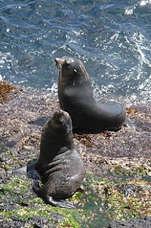
Subantarctic fur seals live on the islands
by the thousands. 
Greg Hofmeyr of the Port Elizabeth Museum is studying layers of fur seal teeth, which grow like tree rings as they age, in order to determine their diets. The seals breed on Tristan Island, and his team will be aboard for three weeks to collect skulls and teeth from any dead seals they find there. Last year they collected got 90 specimens, so I'm picturing a big bag of them being brought by helicopter when we return to the island next month. Recent specimens will be compared to those in museum collections to determine how changes in the environment has affected their diet over the last 50 years.

There's also a French project called Enviroearth that uses monitoring stations on remote islands to detect nuclear explosions. There are arrays of sensors on the ground that pick up seismic waves and some in the air that can detect even the smallest amount of radioactive isotopes. After the madness of the 20th century, an international treaty in 1995 ended nuclear testing. Since then only six detonations have happened (looking at you North Korea). The scientists are also installing renewable energy in the form of solar panels and heaters on houses on the island.

The South African Weather Service has scientists onboard, a few of who will get off at Gough Island to spend a year taking measurements at the station there. It's been monitored for nearly 60 years and the station is getting old, so one of the technicians is stopping at Tristan Island in order to assess relocating the weather station there. Because of the previously mentioned environmental differences between the islands, this raises questions about data continuity. A few of the weather service employees will stay on the ship for the whole trip. They report weather conditions every three hours, which is used to help the captain make navigation decisions, and the data goes to ground truth climate models based on satellite data. On the run south after we leave Gough Island, they will deploy weather balloons and drifting buoys that will further add to the data set.

So there's a lot going on! This is in addition to the 10 scientists who will get off to spend a year on Gough Island, as well as a married couple who will study land birds on Nightingale Island, completely cut off from the rest of the world for six months. And here I thought I lived remotely for long periods of time in order to do science - all of a sudden this five week cruise doesn't seem like such a sacrifice.